The Northern Sustainable Development Research Chair and Caribou Ungava were proud to developed this story map project on caribou and land use. This interdisciplinary project originated from the research project called “Mines and Communities”, which was funded by a research partnership grant from Fonds de recherche du Québec – Nature et Technologie.
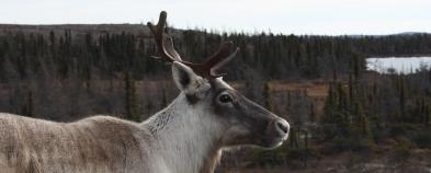
The story map website offers a user-friendly interface that lets the visitors view information on territories, regions, and populations of Northern Québec, infrastructures (roads, active mines, mines under development, and abandoned mines), potential development sites (exploration sites and mining claims), land use and the environmental knowledge of local communities as well as the range of the migratory caribou, migration corridors, and zones of avoidance of human infrastructure. Geospatial data are part of the PhD of Sabrina Plante, under the supervision of Pr Steeve Plante (Laval University), and Isabel Lemus-Lauzon collected data on land use, under the supervision of Pr Thierry Rodon.
Link to the story map website: www.arcg.is/OPbL1